 I am getting ready to start Version 4.0 of the Close up of Sudbury from Henry F. Walling’s Map of Middlesex County, 1856.
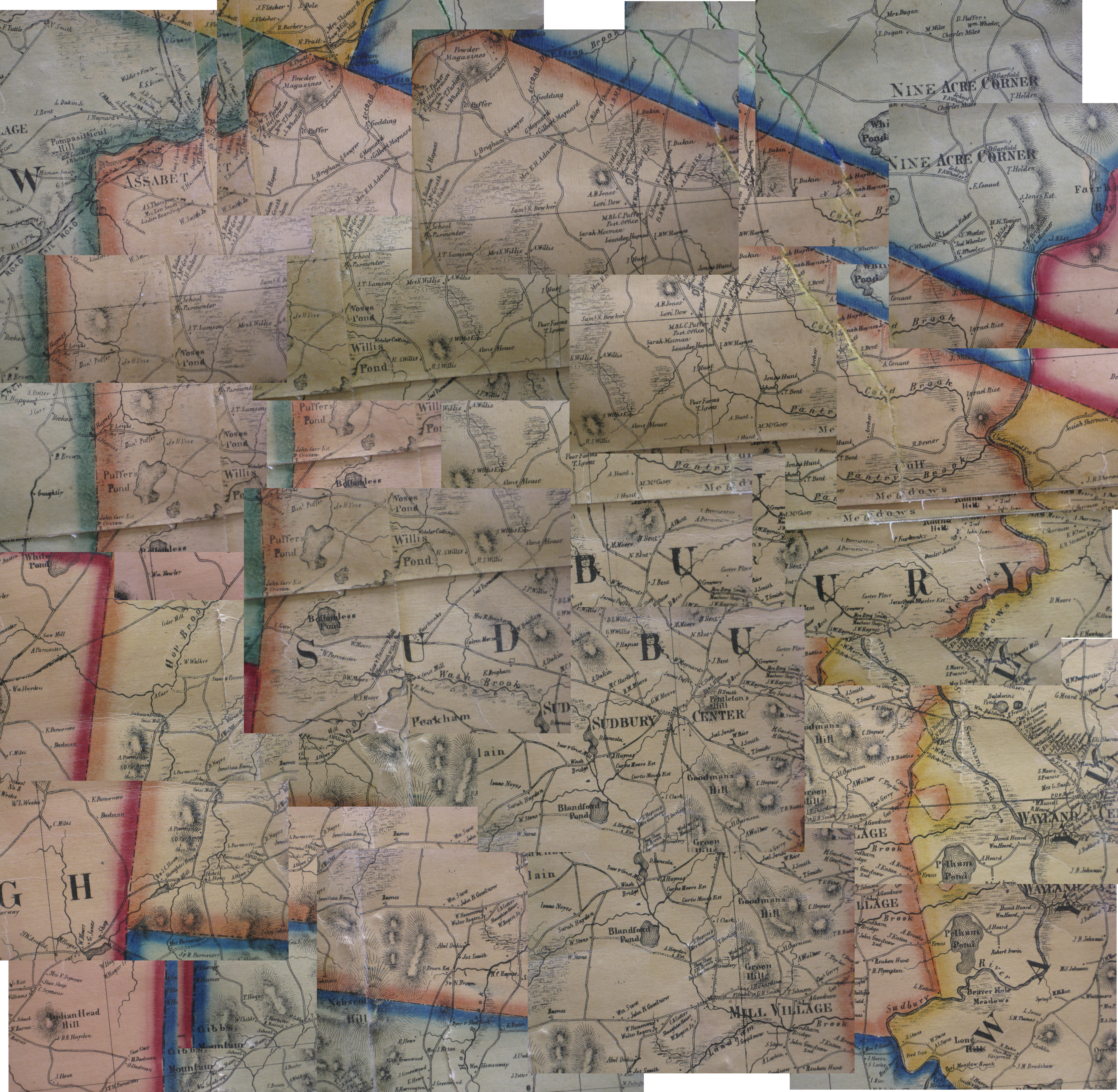
Since there are very few maps of Sudbury (because it was a farming town?) I believe this is the first map after the State mandated 1830 maps (Wood). The version at the Harvard Map Collection (see below) was folded down the middle, so, a wide swath of Sudbury is gone. I took a bunch of photos of the map at the Watertown Free Public Library - inexpertly. However, as I was assembling them, I noticed that the roads do not line up with present roads. Also, this is a 5'x5' map that was printed in at least 4 sheat and Sudbury is right in the middle, so, there are two seems. Since I just have a huge collection of pixels anyway, I decided to make Version 4 match the current Town road map.
Henry F. Walling and the Mapping of New England’s Towns, 1849–1857
By Michael Buehler (PDF)
from The Journal of the Washington Map Society, Issue 71 Spring 2008
"Henry Walling (1825–1888) was arguably the most accomplished...
|
Close up of Sudbury from Henry F. Walling’s
Map of Middlesex County, 1856 Photographed at the Watertown Free Public Library Assembled by YON - Jan C. hardenbergh 2010.12.12 Versions 1.0 -> 3.0 On Dec 8, 2010, at 11:37 AM, Localhistory wrote: The Director pointed out we have a Permission to print policy (see attachment) and think this part pertains to your publishing. "Credit must be given to the Watertown Free Public Library and the creator of the work, if known. For web site use, credit should appear as a part of or next to the image." Thanks again of the photos, Kay Local History Librarian Watertown Free Public Library -----Original Message----- From: YON - Jan C. Hardenbergh [mailto:jch@jch.com] Sent: Thu 12/2/2010 2:16 AM To: Localhistory Subject: Re: Walling's 1856 "Map of Middlesex County, Massachusetts" Here are two sizes of the same image. http://www.hardenbergh.org/places/sudbury/Watertown1856s.jpg (small) http://www.hardenbergh.org/places/sudbury/Watertown1856.jpg Just in case this is ever an issue, I assign the Watertown Free Public Library joint copyright for any purpose, including the right to assign joint copyright to anyone else. For my own part, this is a copy of Walling's work, so, in the public domain now and probably a work by Massachusetts, so, always in the public domain. Also, this came out well: Walling1856TownCenter.jpg And, here is the "before" picture: WallingWFLbefore.jpg It will take a while Thanx again! YON - Jan C. Hardenbergh <> www.jch.com <> Pixelsmith Jeff Lehman's five virtues: a love for complexity, a patient spirit, a will to communicate, a sense of humor, and an optimistic heart. |
 Cap: IMG_2484.JPG |
 Cap: IMG_2484.JPG |
 Cap: IMG_2484.JPG |
Bonnie Burns, Librarian for Geographic Information Services, Harvard Map Collection
 Cap: IMG_2484.JPG |
 Cap: IMG_2487.JPG |
 Cap: IMG_2489.JPG |
|
 Cap: IMG_2485.JPG |
 Cap: IMG_2481.JPG |
 Cap: IMG_2479.JPG |
 Cap: IMG_2477.JPG |
 Cap: IMG_2469.JPG |
 Cap: IMG_2471.JPG |
 Cap: IMG_2473.JPG |
 Cap: IMG_2475.JPG |
 Cap: IMG_2467.JPG |
 Cap: IMG_2466.JPG |
 Cap: IMG_2462.JPG |
 Cap: IMG_2460.JPG |
 Cap: IMG_2454.JPG |
 Cap: IMG_2456.JPG |
 Cap: IMG_2458.JPG |
|
 Cap: IMG_2452.JPG |
 Cap: IMG_2450.JPG |
 Cap: IMG_2449.JPG |
 Cap: IMG_2447.JPG |
 Cap: IMG_2439.JPG |
 Cap: IMG_2440.JPG |
 Cap: IMG_2442.JPG |
 Cap: IMG_2444.JPG |